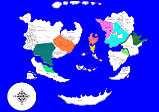
When it came to the geography of The World, I had ideas for some of the political entities and mysterious locations that are to be found in it but no real idea on how they are placed and what the overall map of the world would look like. I asked the aforementioned friend to draw me a world-map that is not of our own world and she went at it and drew some continents and islands on a piece of graphing-paper. She gave it to me and what I had to do next was to fill in the white of the map, make it a habited world. So the basic first version of it looked like this:
 |
| A Carte Blanche, so to speak... |
Now the first thing to say about the map that will result from me tampering with this one is, that it is a medieval map: Not to scale, with large inaccuracies and a lot of guesswork somewhat hampering its usefulness. That said, the map now requires to be populated with cities and empires in order for it to be recognizable as a navigation aid for me as the GM. With some work done, it looks like this:
 |
| Now we're talking... Although I am a bit unhappy about the colours... |
That being said, let's get into the details. In the West you see a large continent that holds two empires and a couple of non-aligned territories. You have the Eastern Empire, which is based on ancient China and probably has the highest density of population in the world. The fertile plains this empire claims for most of its territory are interspersed with sections of woodlands. The Eastern Empire is currently ruled by an Empress, last in line to the holy throne and of a dynasty that traces itself back to an actual god. The Eastern Empire is called thus because, obviously, it covers the Eastern part of its continent.
The Southern part of the West Continent is home to the Empire of Hindustan, a dead-ringer for India, of course. Being a fractured alliance of small god-kingdoms makes this country somewhat unstable but every major settlement is governed not by a human ruler, but by a local deity and these beings do all the internal diplomacy amongst themselves. Other than that I haven't really thought about this culture, as the players are starting out at the other end of the world and I don't even think the plot will ever get them this far away from home...
The Nomad Tribes living in the North of the continent are, of course, representing all central-Asian nomad societies, from Kazakhs, Mongols, Siberians and all these peoples. The free city of Shangri-La, located next to the high-altitude sea on the plateau is somewhat Tibet-inspired, of course. What exactly is going on there, I do not yet know. The Land of Oni is, of course, inhabited by non-human beings. Details are unknown but the city of Portica is actually a colony of the Nation of the the Island of the Rain, which serves as a stop-over place for trade-ships traveling between the Island of the Rain and the Eastern Empire. The Forbidden Lands are actually where Shadow of the Colossus is taking place or something like that. Don't go there.
The smaller continent to the South is home to the Sultanate, which is an amalgam of South East Asian cultures. The pigmy tribes of savages inhabiting most of the continent live in the deep jungles and are a constant threat to that empire.
In the center of the map you see several islands. The Island of the Rain is based on medieval England with a large dose of vikings mixed into it. It is a kingdom having gotten to some wealth by facilitating trade between the two halves of the world. Of course, the inner parts of their lands are still filled with wilderness. The Emerald Isle is, of course, Ireland. The Island of Fog is completely unexplored and may be the domain of a powerful local god/spirit or an ancient civilization of high technological advance. The We - Islands are vulcanic, covered with jungles and filled with dinosaurs, preferably modern, feathered ones. Don't go there either, unless you really need the teeth to impress someone.
Of the four continents to the East, I haven't really thought about the southernmost two. Terra Australia is as of yet empty of meaning, the one above is, of course, a dead-ringer for sub-Saharan Africa. The sizes are, as I said, undetermined, if you look at medieval maps, Europe is often several times the size of Africa, so this continent may actually be huge. The continent to the Northeast of it is Arabia/Northern Africa in nature. The Califate is the major Empire there and has the highest level of science in the entire hemisphere. As one of the player-characters is from there, I'm working on getting a bit more detail into it but it is, obviously centered around that large stream feeding it water and life.
The Western Empire, because there used to be another Eastern Empire, where there are now the Eastern Barbarians, governs quite a bit of its continent, although that is relative, as there are large stretches of unexplored wilderness within its borders. Most life is centered around the two great lakes, while the borders are set by a part of the river system and mountains. As the direct neighbor is the Naga Queendoms, ruling over the large swamps and bogs in the river deltas, the Western Empire is under constant alert. Northern and Eastern Barbarians are essentially early Germans and Slavs before having been christianized.
So that is the map of The World. Next up? I don't know, maybe the more recent history. It's weird if there isn't one and the world is always status quo, isn't it?

No comments:
Post a Comment